1. Context
Broader biophysical and Policy Setting: Tunisia is among the Mediterranean countries most exposed to climate-related vulnerability, with more than 50% of its territory affected or threatened by land degradation. National soil management has historically been guided by the National Strategy for Soil and Water Conservation, with a traditional emphasis on infrastructure-based measures. The current transition toward Land Degradation Neutrality (LDN) calls for more integrated, farmer-oriented, and data-driven landscape management. Zaghouan Governorate exemplifies this challenge: it is a typical semi-arid transition zone of North Africa where land resources face mounting pressure from both climate change and agricultural intensification.
Soil-related Issues: A critical challenge in the Zaghouan region is the mismatch between actual land use and intrinsic soil suitability. The landscape is dominated by cereals (63%) and olives (26%), yet these allocations do not always align with local soil capacity or erosion sensitivity. Growing intensive cereals on fragile, sloping terrain heightens the risk of accelerated soil degradation. Without improved alignment between crop requirements, soil properties, topography, and water availability, land productivity is likely to continue declining. Developing a science-based, participatory crop-use plan is therefore essential to balance production goals, soil conservation objectives, and local community preferences.
The Rmel Soil Living Lab: Situated in a semi-arid environment with 350–600 mm of annual rainfall and varied geological conditions, the Rmel Living Lab is designed to bridge the gap between science and policy. It leverages existing data on soils, climate, land use, and management practices within a structured use-case framework, while building on prior research and stakeholder engagement to convert scientific knowledge into practical tools for crop-use planning.
2. Scale
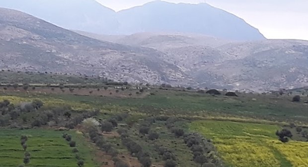
The working landscape encompasses the Wadi Rmel catchment (approximately 675 km²), situated within Zaghouan Governorate in Northeastern Tunisia. The catchment spans a gradient of semi-arid agro-ecological zones and includes a diversity of soil types, land uses, and land tenure arrangements representative of the broader region.
3. Aims
- Environmental & Social: Mitigate and reverse soil degradation while enhancing reservoir water storage to protect ecosystem services and agricultural livelihoods.
- Governance & Integration: Strengthen a multi-stakeholder platform to integrate Soil Data and Information (SDI) and scientific modeling into regional policy and farming practices.
- Strategic Goal: Achieve Land Degradation Neutrality (LDN) through rationalized, participatory land-use planning.
4. Activities
The following activities constitute the initial programme of the Living Lab. Additional tasks and methodologies may be incorporated as the project develops and new priorities emerge in collaboration with stakeholders.
- Soil Information Review & Integration: Compile, harmonise, and integrate existing soil data following a structured Soil Information System (SIS) framework, ensuring consistency across spatial scales and data sources.
- Participatory Diagnosis: Identify barriers, opportunities, and strengths in the effective use of soil information for sustainable landscape management through structured consultations with farmers, technicians, and policymakers.
- Soil Health Indicator Selection: Define a set of policy-relevant and operationally feasible soil health indicators appropriate for the Rmel context, drawing on both scientific literature and local knowledge.
- Field Campaigns: Measure key soil properties and describe representative soil profiles using the standardised SOILS4MED field protocol, providing ground-truth data for modelling and decision-support tools.
- Use-Case Identification: Define specific, actionable use cases for applying the Soil Information System to achieve sustainable soil landscape management goals — including crop-use planning, erosion risk mapping, and LDN monitoring.
- Use-Case Piloting: (a) Develop a science-based framework for soil-suited crop allocation across the landscape; (b) co-design and iteratively refine the framework with local stakeholders through participatory spatial planning sessions.
- Capacity Building: Deliver a structured programme of expert consultations, participatory workshops, computer-lab training sessions on soil information systems and decision-support tools, and field-based evaluations of soil health indicators.
5. Participants
The following organizations and groups constitute the initial stakeholder list; the partnership remains open to additional contributors from the local and international community.
- Science: INRGREF (Coordinator), ICARDA, ESA Mograne, IRA Medenine, and INRAT.
- Policy – Decision-making: Direction Générale de l’aménagement et de la Conservation des Terres Agricoles (DGACTA).
- Policy – Implementation: Commissariat Régional de Développement Agricole (CRDA-Zaghouan).
- Practice: Local farmers of the Rmel catchment.
- Civil Society: The Zaghouan Farmer Association.